
Three Key Factors Behind Texas’ Devastating Floods: Why They’re So Extreme and Deadly
Jennifer USA

Texas has faced its share of natural disasters, but few are as destructive and heartbreaking as the state’s recurring floods. From the catastrophic flooding of Hurricane Harvey in 2017 to the more recent devastation caused by Hurricane Beryl in 2024, Texas floods have left communities reeling, claiming lives and causing billions in damage. What makes these floods so extreme and deadly? Here, we break down the three key factors driving the intensity of these disasters.
1. Intense Rainfall and Climate Change
Texas is no stranger to heavy rain, but recent floods have been amplified by increasingly extreme weather patterns. Climate change has supercharged storms, leading to torrential downpours that overwhelm the state’s infrastructure. For example, during Hurricane Beryl in July 2024, parts of East Texas saw up to 15 inches of rain in just a few days, causing rivers and creeks to swell beyond capacity. Warmer air holds more moisture, and rising global temperatures mean storms can dump unprecedented amounts of water in short periods. This “rain bomb” effect turns even minor storms into catastrophic flooding events, leaving little time for preparation or evacuation.
2. Urbanization and Poor Drainage Systems
Texas’ rapid urban growth, particularly in cities like Houston, has exacerbated flood risks. Sprawling development replaces natural landscapes with impermeable surfaces like concrete, preventing water from being absorbed into the ground. Houston, one of the hardest-hit areas in recent floods, has seen its wetlands and prairies diminish, reducing the land’s natural ability to manage runoff. Compounding this issue are outdated or inadequate drainage systems that can’t handle the volume of water during extreme storms. When heavy rains hit, water pools in streets, neighborhoods, and highways, turning urban areas into deadly flood zones. In 2024, reports highlighted how clogged or undersized drainage systems contributed to widespread inundation during Beryl’s aftermath.
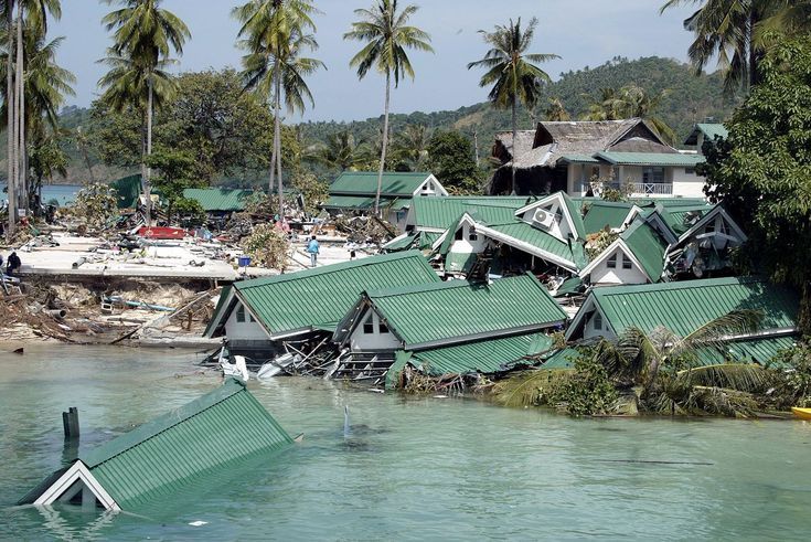
3. Geographic Vulnerability and Storm Surges
Texas’ geography plays a significant role in its flood-prone nature. The state’s low-lying coastal plains, combined with its proximity to the Gulf of Mexico, make it a prime target for hurricanes and tropical storms that bring storm surges and heavy rainfall. Areas like Galveston and Corpus Christi face the double threat of inland flooding and coastal surges, which can push seawater miles inland, submerging homes and infrastructure. During Hurricane Beryl, storm surges of up to 7 feet compounded inland flooding, trapping residents and complicating rescue efforts. The flat terrain and slow-draining rivers, like the San Jacinto and Trinity, further prolong flooding, increasing the risk to lives and property.
إرسال تعليق